INTERNET RADAR AND VIRTUAL VESSEL TRAFFIC SERVICE
K. Hasegawa* and K. Taniguchi**
* Osaka University
** Mitsubishi Electric, Co. Ltd.
(at the time of this research; Osaka University)
Abstract
In this paper, new concept of operational aids for safety navigation is proposed: Internet radar and virtual vessel traffic service (V-VTS). These are within the same concept, fully utilized by Internet. Each ship has a PC connected to Internet through certain satellite communication system, and can communicate with a PC/EWS, in which data from all communicatable ships are accumulated and updated. The PC/EWS can be regarded as a virtual vessel traffic service (V-VTS). Each ship will send her own data to V-VTS and get these data of others in return automatically and regularly. On her PC, captain can browse radar image and get detail data of any ship displayed on the Internet Radar by clicking it. The system is evaluated by simulation.
Introduction
For safety of navigation in congested waterways, radar plays an important role. ARPA (Automated Radar Plotting Aids) or ECDIS (Electric Chart Display and Information System) are recently added as additional operational aids. However, the number of ship casualties doesn’t change drastically for these ten years, or number of big disasters such as oil spills rather increases.
On the other hand, rapid progress in Internet, GPS and satellite communication have brought us various changes in technology. Combining these technologies, we came up to an idea[1]. In this paper, the idea was realized and evaluated through computer network simulation. One of the authors is also utilizeing Internet technology for initial ship design, especially for manoeuvrability assessment[2]. JavaTM, a comupter language suitable for network computing, is used for the purpose of security, machine independence and host load reduction. In this study JavaTM is used again, but for graphic purpose.
Virtual Vessel Traffic Service (V-VTS) System[1]
The concept of the system was very simple as shown in Fig. 1[1].
Fig. 1 Concept of V-VTS system
In the figure, Ships A, B and C are V-VTS accessible ships, which can send own data to V-VTS via satellite communication periodically. In return they will get data of other ships accessed to V-VTS. On the other hand , ships D, E and F are V-VTS unaccessible ships, whch can get data of others only by radar. If V-VTS is equipped with radar, it is possible to digitize the image and can send position data of even Ships D, E and F to all V-VTS accessible ships. However, in this paper, V-VTS is treated as “virtual”, so not necessarily equipped radar. We can create V-VTS anywhere in the world.
Database, Interface and Internet Radar
The V-VTS is regarded as a database accessible from the network. For the network interface, we use HTML, CGI and JavaTM. Each ship will access the V-VTS through a web browser such as Netscape or Internet Explorer. The V-VTS requests to get the initial data to create a record. From that time, each time the ship updates her data, she will receive data of other ships as well as chart information. The data is handled by JavaTM and the following window will pop up.
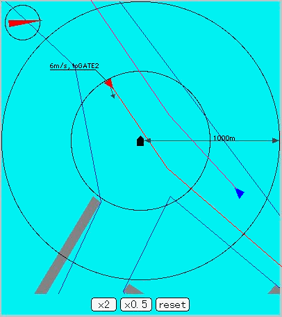
In the figure, the own ship is displayed in the centre and other ships are shown with their plan paths and present velocity vector. In the figure, upper-left ship coming southward will meet with the own ship, so that she has changed her course to avoid collision. It will be helpful to ship masters to provide these data without any manual operation or communication.
Fig. 2 Internet radar image
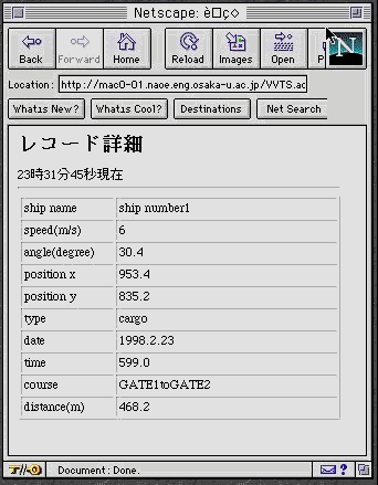
Fig. 3 Detail of a record shown on a client’s browser (sample)
Moreover, if the ship master clicks either of ship images, detail of the data will be tabulated as shown in Fig. 3.
Information to be Provided and not to be Provided
In this paper, we don’t much care of the database structure, because the main purpose is to realize the system in computer network simulation. However, it will be more important to discuss on this matter.
Communication Protocol
Another item to be discussed in the future is communication protocol. There are already a few standard protocol for ship management[3]. We need careful watch on the progress in this field.
Internet Ship Handling Radar Simulator
The basic structure of the simulation system is shown in Fig. 4. The marine traffic simulation system (SMARTS)[4] was developed using ship auto-navigation fuzzy expert system (SAFES)[5]. It can automatically create marine traffic according to the statistical data etc. and each ship will be operated by SAFES based on regulations, captain’s knowledge and experience. This study added another capability to this system: i.e. anyone can create his/her own ship to this virtual marine traffic and other ships will navigate safely including the added ship’s behaviour. It can be regarded as Internet Ship Handling Radar Simulator. The client only needs suitable web browser.
Fig. 4 Whole structure of simulation system
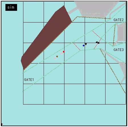
Fig. 5 Virtual or reality? – sample output of marine traffic simulation system
Conclusions
The paper didn’t deal with the method-ology in detail, but only demonstrates how network computing will be practically useful and how it will be done. The main conclusions to be drawn are summarized below.
This study was supported by a Grant-in-aid for Scientific Research, Monbusho, Japan.
References